
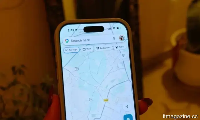
Each call you make is helping to create a map of your city, and it could potentially alleviate our traffic issues.
You don’t actually need to disclose your location for your city to determine your whereabouts. Every call you make and every message you send connects seamlessly to a nearby network antenna. When this is multiplied across millions of users doing the same thing daily, it results in more than just data — it creates a dynamic, real-time depiction of a city’s functionality. Researchers at the University of Córdoba have successfully utilized this with a new tool designed to analyze these patterns.
The tool that observes without truly watching
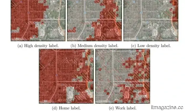
MAPLID (Multi-label Approach for Place Identification) does not track individuals. Instead, it focuses on patterns — aggregated, anonymized signals that illustrate how different areas operate over time. It can indicate when a neighborhood transitions from residential to commercial, when roads approaching industrial zones experience peak traffic, or how a single large event can subtly disrupt the flow of an entire area.
What distinguishes it is its ability to recognize multiple definitions for a place. For instance, a university campus is not solely a workplace; depending on the hour, it can also serve as a home, a social gathering spot, or a transit route. Most mapping tools tend to assign a singular label to a location, whereas MAPLID captures all these overlapping dimensions simultaneously.
How the research operates
The model was created as part of the doctoral research of Manuel Mendoza Hurtado, alongside colleagues Juan A. Romero del Castillo and Domingo Ortiz Boyer from the Department of Computer Science and Artificial Intelligence.
Instead of analyzing raw location traces, the system develops its understanding in layers. It begins with geolocated call and message metadata — not the content itself, but the connection points that log when devices interact with network antennas. It then monitors how these signals are repeated over days and weeks, distinguishing consistent routines from sporadic movements. This behavioral data is then compared with OpenStreetMap, an open-source geographic database, which provides real-world context like street types, landmarks, and building classifications, transforming abstract signal patterns into something much more applicable for urban analysis.
What emerges from this methodology is a time-lapse effect. The same street block, observed at different hours, can narrate entirely different stories — the scene at 7 am appears vastly different from that at 7 pm. To validate the model, the team tested it in Milan and Trento, two Italian cities that vary significantly in size and structure, making them suitable for comparison. Due to privacy limitations, Spanish mobile data was inaccessible, so the researchers used a dataset provided by Telecom Italia for scientific study. Even while layering millions of daily data points onto urban maps, the model remained robust across both cities, suggesting its applicability extends beyond a single type of urban environment.
The findings have been published in the International Journal of Geographical Information Science.
So, who is monitoring this?
Currently, there is no official usage of the tool. The researchers' next step is to present it directly to local governments and city planners. The potential applications are quite clear — modifying bus schedules based on actual movement patterns, enhancing traffic management in real congested areas, and even dispatching cleaning crews to locations that genuinely require attention, rather than relying on outdated assumptions.
The fascinating aspect is that cities have always generated this kind of information; it was never absent. What has been lacking is a means to interpret it meaningfully and usefully. This tool could be the pivotal advancement needed to achieve that.
Other articles
 Every call you place is creating a map of your city, and it could potentially help solve our traffic problems.
A group of researchers has developed a tool that visualizes the functioning of cities by utilizing only anonymous cell phone data.
Every call you place is creating a map of your city, and it could potentially help solve our traffic problems.
A group of researchers has developed a tool that visualizes the functioning of cities by utilizing only anonymous cell phone data.
 KitKat features a unique chocolate wrapper that disconnects your phone from the external environment.
KitKat has introduced a chocolate wrapper that functions as a Faraday cage, effectively blocking all phone signals as soon as your device is placed inside.
KitKat features a unique chocolate wrapper that disconnects your phone from the external environment.
KitKat has introduced a chocolate wrapper that functions as a Faraday cage, effectively blocking all phone signals as soon as your device is placed inside.
 Wagering on human enhancement, is it likely that lightweight exoskeletons will become common?
Hypershell is aiming to establish a new category that combines wearables and robotics. The Chinese startup specializes in lightweight exoskeletons.
Wagering on human enhancement, is it likely that lightweight exoskeletons will become common?
Hypershell is aiming to establish a new category that combines wearables and robotics. The Chinese startup specializes in lightweight exoskeletons.
 Motorola's latest Razr Ultra foldable is more attractive than before, and it comes with a higher price tag as well.
The new Razr Ultra from Motorola is visually impressive with its Alcantara and wood finishes, featuring a larger battery, enhanced durability, and a higher launch price of $1,499.99.
Motorola's latest Razr Ultra foldable is more attractive than before, and it comes with a higher price tag as well.
The new Razr Ultra from Motorola is visually impressive with its Alcantara and wood finishes, featuring a larger battery, enhanced durability, and a higher launch price of $1,499.99.
 Your Google TV experience is set to become more dynamic with a specific YouTube Shorts feed.
The recent Google TV update will introduce YouTube Shorts to the home screen this summer through a new "Short videos for you" section, although there are no confirmed options to opt out.
Your Google TV experience is set to become more dynamic with a specific YouTube Shorts feed.
The recent Google TV update will introduce YouTube Shorts to the home screen this summer through a new "Short videos for you" section, although there are no confirmed options to opt out.
 Motorola's upcoming budget smartphone has been revealed in two Pantone colors and is set to feature a 200MP camera.
The Moto G87 has appeared in credible-looking renders leaked by Evan Blass, showcasing a 200MP main camera with OIS, a design reminiscent of the G-series, and Pantone color selections.
Motorola's upcoming budget smartphone has been revealed in two Pantone colors and is set to feature a 200MP camera.
The Moto G87 has appeared in credible-looking renders leaked by Evan Blass, showcasing a 200MP main camera with OIS, a design reminiscent of the G-series, and Pantone color selections.
Each call you make is helping to create a map of your city, and it could potentially alleviate our traffic issues.
A group of researchers has developed a tool that illustrates how cities function, utilizing only anonymous cell phone data.