Every call you place is creating a map of your city, and it could potentially help solve our traffic problems.
You don't need to explicitly share your location for your city to determine where you are. Whenever you make a call or send a message, you connect to a nearby network antenna. When this activity is multiplied by millions of people engaging in the same actions daily, the result is not just data — it creates a dynamic and accurate representation of a city's functioning. Researchers at the University of Córdoba have successfully tapped into this with a new tool designed to analyze these patterns.
The tool that observes without actually observing
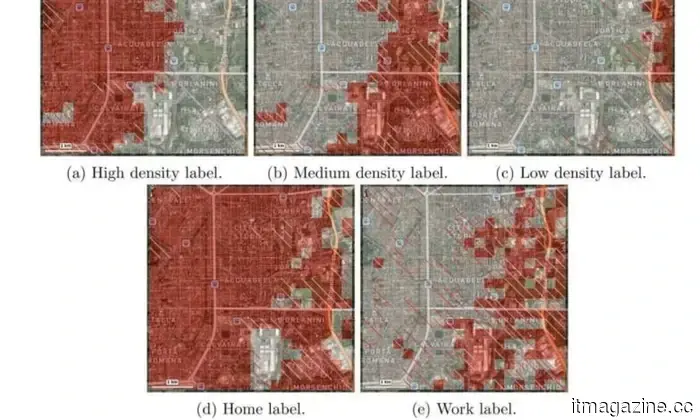
MAPLID (Multi-label Approach for Place Identification) does not track specific individuals. Instead, it examines patterns — aggregated and anonymized signals that reflect how locations function over time. It can indicate when an area transitions from residential to commercial use, when traffic to industrial zones peaks, or how a significant event can subtly alter the flow of an entire neighborhood.
What sets it apart is its ability to capture the multiple facets of a location. For instance, a university campus is not solely a workplace; depending on the time of day, it can also serve as a home, a social hub, or a transit corridor. Unlike most mapping tools that tend to assign a single label, MAPLID encompasses all these dimensions simultaneously.
Understanding the research methodology
The model was developed as part of doctoral research by Manuel Mendoza Hurtado, alongside colleagues Juan A. Romero del Castillo and Domingo Ortiz Boyer from the Department of Computer Science and Artificial Intelligence.
Rather than relying on raw location data, the system builds its understanding in layers. It begins with geolocated metadata from calls and messages — not the content itself, but the connection points that are triggered when devices connect to network antennas. It then analyzes how these signals vary over days and weeks, helping distinguish routine behaviors from isolated movements. This behavioral data is then aligned with OpenStreetMap, an open-source geographic database, providing real-world context such as street types, landmarks, and building classifications, thereby transforming abstract signal patterns into a more practical format for urban analysis.
The outcome of this approach is akin to a time-lapse. The same street block can tell entirely different stories at various times — for example, 7 AM looks vastly different from 7 PM. To evaluate the model, the team applied it to Milan and Trento, two Italian cities that differ significantly in size and layout, making them ideal for comparison. Due to privacy regulations, Spanish mobile data was unavailable, so the researchers utilized a dataset provided by Telecom Italia for academic research. Despite layering millions of daily data points onto urban maps, the model performed consistently across both cities, indicating its applicability across diverse urban environments.
The study has been published in the International Journal of Geographical Information Science.
So, who is actually monitoring this?
Currently, no one is officially utilizing it. The researchers’ next step is to present the tool directly to local governments and city planners. The potential applications are quite evident — adjusting bus schedules according to actual movement patterns, enhancing traffic flow in congested areas, and dispatching cleaning crews to locations that truly require their attention, rather than relying on outdated assumptions.
The intriguing aspect is that cities have always generated this type of information; it has never been absent. What has been lacking is a method to interpret it in a meaningful and practical manner. This tool could very well be the advancement needed to bridge that gap.
Другие статьи
 Wagering on human enhancement, is it likely that lightweight exoskeletons will become common?
Hypershell is aiming to establish a new category that combines wearables and robotics. The Chinese startup specializes in lightweight exoskeletons.
Wagering on human enhancement, is it likely that lightweight exoskeletons will become common?
Hypershell is aiming to establish a new category that combines wearables and robotics. The Chinese startup specializes in lightweight exoskeletons.
 Motorola's latest Razr Ultra foldable is more attractive than before, and it comes with a higher price tag as well.
The new Razr Ultra from Motorola is visually impressive with its Alcantara and wood finishes, featuring a larger battery, enhanced durability, and a higher launch price of $1,499.99.
Motorola's latest Razr Ultra foldable is more attractive than before, and it comes with a higher price tag as well.
The new Razr Ultra from Motorola is visually impressive with its Alcantara and wood finishes, featuring a larger battery, enhanced durability, and a higher launch price of $1,499.99.
 KitKat features a unique chocolate wrapper that disconnects your phone from the external environment.
KitKat has introduced a chocolate wrapper that functions as a Faraday cage, effectively blocking all phone signals as soon as your device is placed inside.
KitKat features a unique chocolate wrapper that disconnects your phone from the external environment.
KitKat has introduced a chocolate wrapper that functions as a Faraday cage, effectively blocking all phone signals as soon as your device is placed inside.
 Gemini can now convert your chat into a completed PDF, Word document, or spreadsheet with just one tap.
Request Gemini to compose a piece, choose a format, and download the completed file; that's all. No need to change apps, reformat, or copy.
Gemini can now convert your chat into a completed PDF, Word document, or spreadsheet with just one tap.
Request Gemini to compose a piece, choose a format, and download the completed file; that's all. No need to change apps, reformat, or copy.
 Banking on human enhancement, will lightweight exoskeletons become widely adopted?
Hypershell aims to establish a new category that merges wearables and robotics. This Chinese startup specializes in developing lightweight exoskeletons.
Banking on human enhancement, will lightweight exoskeletons become widely adopted?
Hypershell aims to establish a new category that merges wearables and robotics. This Chinese startup specializes in developing lightweight exoskeletons.
 Your Google TV experience is set to become more dynamic with a specific YouTube Shorts feed.
The recent Google TV update will introduce YouTube Shorts to the home screen this summer through a new "Short videos for you" section, although there are no confirmed options to opt out.
Your Google TV experience is set to become more dynamic with a specific YouTube Shorts feed.
The recent Google TV update will introduce YouTube Shorts to the home screen this summer through a new "Short videos for you" section, although there are no confirmed options to opt out.
Every call you place is creating a map of your city, and it could potentially help solve our traffic problems.
A group of researchers has developed a tool that visualizes the functioning of cities by utilizing only anonymous cell phone data.