The 'Space Umbrella' has sent back its initial stunning images of the forests on Earth.
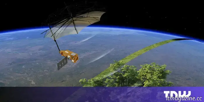
A large umbrella-like satellite incorporating European technology has produced its first images of the Earth’s surface. The satellite, known as “Biomass,” was developed by various aerospace companies and startups for the European Space Agency (ESA). It was launched in April using a Vega-C rocket from the European spaceport in Kourou, French Guiana. European Astrotech, a startup based in the UK, was responsible for fueling the satellite prior to launch.
Biomass is tasked with capturing unparalleled measurements of forest carbon from space. It is equipped with the first-ever P-band radar to orbit our planet, which will enhance our understanding of transformations within the Earth's forests and their effect on the global carbon cycle. Developed by Airbus, this radar instrument operates with long wavelengths that can penetrate dense canopies to access the woody structures beneath, where a significant portion of a forest's carbon is sequestered.
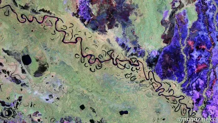
In addition to forests, the satellite can also map geological formations beneath deserts, analyze ice sheet structures, and detail the topography of forest floors. An image featuring the Rio Beni winding through Bolivia's rainforests was created utilizing the radar instrument’s various polarization channels, with colors reflecting specific landscape characteristics. For example, green shades indicate rainforest, red hues denote forested floodplains and wetlands, and blue to purple suggests grasslands, while black areas signify rivers and lakes.
Biomass orbits Earth in a Sun-synchronous trajectory at approximately 666 kilometers above the surface. It sends raw radar data from its P-band instrument to ESA’s ground station in Kiruna, Sweden, where the information is received and forwarded to processing facilities. The data is then calibrated and converted into valuable scientific products, such as biomass density maps and models of forest height.
Once processed, these datasets are made available via a Multi-Mission Algorithm and Analysis Platform (MAAP), developed by the Belgian technology company Spacebel. This platform enables scientists globally to search, access, and analyze Biomass data directly in the cloud, eliminating the need to download large files or handle complicated infrastructure.
The function of the large umbrella is to direct radar pulses from the P-band radar instrument located on the satellite’s body down to the forests below. When these radar signals reach the Earth's surface, they bounce back. The umbrella-shaped antenna, constructed by US aerospace company L3Harris, captures the returning signals and sends them to the satellite. The onboard systems then process this data to produce detailed 3D maps of global biomass and other landscape features.
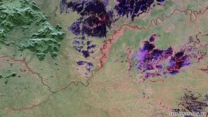
One image displays the Amazon rainforest in northern Brazil, where pink and red colors indicate wetlands, with red hues highlighting forested floodplains along the river. In contrast, the northern section, depicted in deep green, shows more rugged terrain and dense forest cover. Michael Fehringer, ESA’s project manager for Biomass, mentioned that the satellite is currently in its commissioning phase, a period for testing and calibration following its launch, and he anticipates collecting even better data in the future. He added, “Biomass is outfitted with innovative space technology, and we’ve been closely observing its performance in orbit. We’re delighted to report that everything is operating smoothly, and its initial images are truly remarkable — just a glimpse of what is yet to come.”
Other articles
The 'Space Umbrella' has sent back its initial stunning images of the forests on Earth.
A massive satellite resembling an umbrella, equipped with European technology, has unveiled its initial images of the Earth's surface.